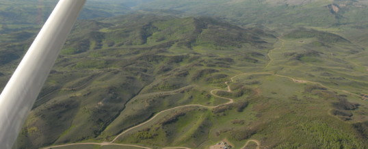
The stewardship responsibility of Colorado West Land Trust, the partnership between Mesa Land Trust and Black Canyon Regional Land Trust, is an enormous undertaking. Between the two organizations there are 543 separate conservation easements covering over 120,000 acres across the service area that must be monitored each year by staff members, volunteers and contractors.
Annual monitoring visits and the related hours spent entering information and compiling reports takes the CWLT staff thousands of hours each year. To make the process more efficient, Diana Cort, Director of Conservation and Jeremy Puckett, Stewardship Director utilize aerial monitoring techniques.
Through aerial monitoring, what can take hundreds of hours on the ground to accomplish can be completed over the course of only a few hours. This monitoring method is highly efficient and allows our staff to easily observe expansive projects (such as fence maintenance on hundreds of acres) and hard-to-reach projects (such as pond construction in remote canyons).
LightHawk, a non-profit environmental aviation organization, provides support to this effort by coordinating the services of highly-skilled volunteer pilots to offer flights designed to increase the efficiency and effectiveness of their partnering organizations. This service helps CWLT and other conservation groups save time and money, which can be invested in more pressing stewardship issues.
This year the land trust’s monitoring program is scheduled to complete aerial monitoring on 70 properties covering over 30,000 acres across the 6-county service area using LightHawk and charter flight service. Click here to learn more about LightHawk.
From the LightHawk Website
Black Canyon Regional Land Trust
7/21/2017
A suite of LightHawk flights enabled Black Canyon Regional Land Trust to conduct their annual conservation easement monitoring much more efficiently than they could from the ground.
The aerial perspective allows them to view conserved properties within the context of a dynamic, changing landscape. Whether it’s development pressure, landscape-scale habitat conversion or other challenges, the ability to view properties from the air helps to anticipate change and identify potential threats that could one day impact conserved properties.
ShareJUN
2018
